Geoarchaeology
Stélida Chert
The Stélida chert was first described by Séfériadès (1983) as a form of chert close to chalcedony, occasionally veined, often fractured, and ranging in colour from white, to blue, to pink, and generally considered to be of relatively poor quality.
Institute of Geological and Mining Exploration
A key component of SNAP’s work is the geoarchaeological survey, undertaken by Prof. Nikos Skarpelis (with the help of Dan Contreras), who has extensive geological knowledge of the Cyclades and has previously undertaken a mineralogical study of Stélida. This work was work undertaken with a permit from the Institute of Geological and Mining Exploration.
Mineralogical study of Stélida
The aim of this work was:
- to map and characterise the chert outcrops in terms of the raw materials’ accessibility, colour, macro/micro-texture, banding inter alia, and its knapping quality,
- to document intra-source chert variability, particularly as related to its use as a lithic raw material by integrating the geological observations with the artefact distribution,
- to collect a representative number of geo-referenced geological samples (Figure 1) for petrographic and elemental characterisation of the chert back at Prof. Skarpelis’ laboratory in Athens,
- to use this characterisation data to map the distribution of Stélida chert elsewhere in Naxos and the southern Aegean as a means of reconstructing the procurement and exchange networks that came together at the source.
Firstly, the Stélida rock pile occurs as thick tabular beds and can be petrographically characterized as a brittle, massive, pervasively silicified sedimentary rock (Figure 2).
It is very hard, with conchoidal fracturing, semivitreous, vitreous, or waxy lustre. The colour of the rock is very light grey to white, locally light grey with a honey hue (Figure 3).
Secondly, the best quality chert is located at the southern peak of Stélida, outcropping to the immediate east and western flanks.
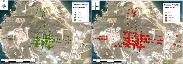
Thirdly, the rock becomes much sandier and less easy to flake as one walks northwards along the ridge (with a few exceptions), which may largely explain the notable drop-off in material culture along those transects (Figure 5). Fourthly, good quality raw material is also exposed at the base of a modern quarry at the north-eastern flank of the headland; however the depth of this chert means that it was probably inaccessible to prehistoric peoples.

Future Directions
Much more information is to come from this study, not least after the completion of the petrographic analyses (using both a petrographic microscope and a Scanning Electron Microscope [SEM]), and the elemental characterisation analyses of the geological samples using Inductively Coupled Plasma – Mass Spectroscopy [ICP-MS].
In 2014, we were interested in characterizing the nature of patination of our artefacts across the site, to see if the different types of weathering we see on the stone tools are indices of age and/or local processes of exposure and erosion.